
Sections
Highlight

María Albert
Madrid
Monday, 20 January 2025, 10:24
The arrival of the storm Garoé in Spain is set to bring a new change in the weather across much of the country. This has been announced by the Agencia Estatal de Meteorología (Aemet) a few hours ago, anticipating a few days that will be marked by «abundant rain» on the Spanish mainland, snow in some mountain areas and strong winds. According to experts, it will be the heaviest episode of rain since 2025 began.
The period from 20 to 26 January will be, according to the agency, a very unstable week in most of the country, where the storm will leave strong winds between Monday and Wednesday. In addition to all this, there will also be freezing rain, which could form sheets of ice on roads, which is why Aemet is calling for extreme caution when travelling by car due to the danger this could cause.
⚠️NOTA INFORMATIVA | La borrasca Garoé propiciará un cambio de tiempo.
— AEMET (@AEMET_Esp) January 18, 2025
→ Lluvias abundantes en el oeste peninsular, especialmente en Andalucía occidental y Extremadura.
→ Vientos intensos del sur y ascenso térmico: nieve en alta montaña
(Tuit 1 de 2)
🔗https://t.co/oW7JOzMIDU pic.twitter.com/p8rWt0OJ4N
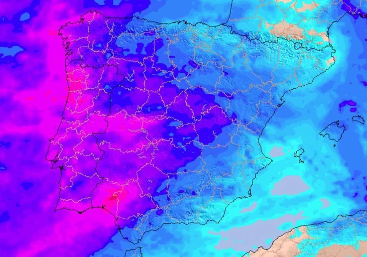
The Aemet models are already warning that the next few days will be very wet in a large part of Spain due to the arrival of storm Garoé. It is expected that along with this «widespread rainfall in the » there will also be a change in the thermometers: from the sub-zero temperatures of last week we will move to a much milder and milder atmosphere, with rising values.
From this Monday 20 January onwards, the rains will spread from the north-western third of the Spanish mainland to the rest of the Iberian Peninsula. The most affected regions, according to Aemet, will be those on the Atlantic side, especially Andalucía, Extremadura, Castile y Leon and Galicia , where up to 90mm could fall in the next few hours.
🔴 #ÚltimaHora La #BorrascaGaroé 🌀 traerá un cambio de tiempo radical a España, con acumulados de lluvia 💦 de más de 150 l/m2 en algunas zonas.
— Meteored | tiempo.com (@MeteoredES) January 19, 2025
👇 No te pierdas la previsión actualizada de @DuncanWingen:https://t.co/tQ9PfQEqya pic.twitter.com/rjJ5p5cQhA
In these areas of the southwest quadrant, warned Aemet, we could have precipitation that «occasionally could be heavy and be accompanied by thunderstorms«. «It is likely that between Monday 20 and Wednesday 22 more than 100-150 mm will accumulate in this area, especially on the southern slopes of Sierra Morena and the western Central system,» warn the meteorologists.
Over the next few days, we will leave behind the low temperatures of the last week, with thermometers rising thanks to the arrival of mild and very humid winds driven by storm Garoé. We will say goodbye to the heavy frosts, although we will still be cold in some northeastern regions this Monday.
❄️Borrasca Garoé | Nevadas a partir de 800 metros en Castilla y León y sur de Galicia entre la tarde-noche del domingo y la mañana del lunes.
— AEMET (@AEMET_Esp) January 19, 2025
Aviso naranja en la meseta de León. Las nevadas pueden afectar a vías de comunicación importantes. Consulta el estado de las carreteras. pic.twitter.com/35M2fbCvLV
Frosts will continue to take their toll in Catalonia, Aragon, La Rioja and some parts of Castilla-La Mancha and the Madrid regions. In addition, snowfall above 800 metres will continue in Castilla y León and southern Galicia during Monday morning, according to Aemet. On Tuesday we could also see flakes in the Pyrenees, where precipitation could be heavy.
The thermal situation will change from Wednesday onwards, with slightly milder minimum temperatures across almost the entire mainland, where nighttime temperatures will not drop below 5C in the interior and northern plateau. On the other hand, on the same day, mercury is expected to soar in areas of the southeast and the Mediterranean, where highs will easily exceed 20C.
Publicidad
Publicidad
Publicidad
Publicidad
Esta funcionalidad es exclusiva para registrados.
Reporta un error en esta noticia

Debido a un error no hemos podido dar de alta tu suscripción.
Por favor, ponte en contacto con Atención al Cliente.

¡Bienvenido a SURINENGLISH!

Tu suscripción con Google se ha realizado correctamente, pero ya tenías otra suscripción activa en SURINENGLISH.
Déjanos tus datos y nos pondremos en contacto contigo para analizar tu caso

¡Tu suscripción con Google se ha realizado correctamente!
La compra se ha asociado al siguiente email
Comentar es una ventaja exclusiva para registrados
¿Ya eres registrado?
Inicia sesiónNecesitas ser suscriptor para poder votar.