Aemet puts Spain on alert for episodes of extreme heat and storms
In the coming hours, the state agency will activate warnings for heavy rain as well as alerts for high temperatures in many regions
María Albert
Madrid
Wednesday, 18 June 2025, 10:06
The last few hours in Spain have already begun to show the first signs of the hot week that awaits us in much of the country. According to the state meteorological agency (Aemet), over the next few days the summery atmosphere will leave yellow and amber warnings for high temperatures and thunderstorms which will be "locally very strong".
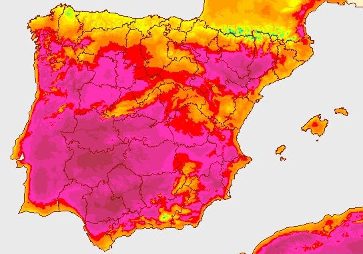
In general, the agency points out that we will have a few days of intense heat, "with maximum and minimum temperatures above normal" in many areas of the country. The values will be around 35C in many regions, while, from Wednesday onwards, in some parts of the south we could see the mercury hit above 40C and tropical nights above 22 degrees.
Despite this episode of high temperatures, weather instability will continue to play a leading role in certain parts of the interior of the Spanish mainland. In fact, according to experts, during this week we will have "building cloudiness and strong local showers accompanied by thunderstorms, hail and strong or very strong gusts of wind" in some Spanish provinces.
Predicción semanal:
— AEMET (@AEMET_Esp) June 16, 2025
⛈️ Todos los días en el interior peninsular nubosidad de evolución y chubascos locales fuertes y acompañados de tormenta, granizo y rachas de viento fuertes o muy fuertes.
🌡️Intenso calor, con máximas y mínimas por encima de lo normal, excepto en Canarias. pic.twitter.com/GmXcNrKpq3
New episode of extreme heat: the areas of Spain seeing more than 40C this week
The arrival of a warm air mass from North Africa has brought a new rise in temperatures to Spain. Along with this thermal rise, some suspended dust will also arrive, leaving 'calima' (Sahara desert sand dust in suspension in many areas of the Spanish mainland, especially in the western part of the country, where we will have some muddy showers due to these particles.
The extreme heat of these days will spread throughout Spain from this Wednesday, which will probably be the hottest day of the week. As a result, thermometers will approach those of the 'canícula', the hottest period of the year incorporating the last two weeks of July and the first week of August, and in many provinces we will see values of between 8 and 12C above normal for the season.
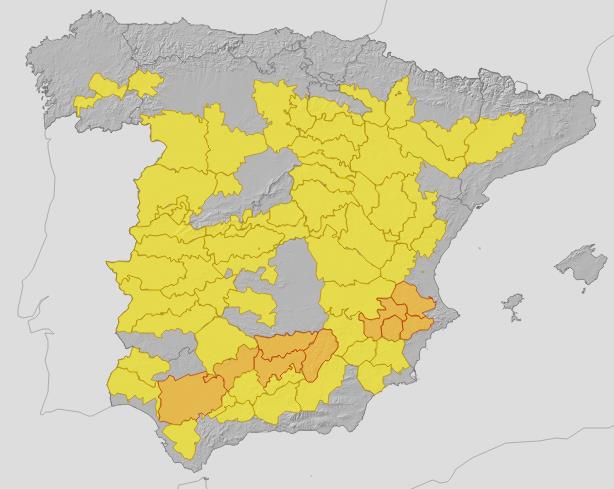
Throughout the day, temperatures will reach 37C in much of the inland areas of the mainland and even 42C in cities such as Badajoz, Seville, Jaen and Cordoba. Aemet has already activated yellow warnings for high temperatures in the regions of Galicia, Castilla y León, Madrid, Extremadura, Castilla-La Mancha, Andalucía, Murcia, Aragón and Catalonia.
During these days, the nights will also be very warm and almost tropical, with temperatures not dropping below 22 to 24C in the Mediterranean and other southern areas.
When will temperatures drop? Aemet forecasts the end of the heat episode
With regard to temperatures, everything points to the fact that in the next few days we could see a change that will affect some provinces in Spain. This is what the Aemet has warned in its forecast for these days, where it warns that, from Thursday onwards, temperatures could suffer a slight drop. This drop in temperatures will be more noticeable in Galicia and in the far west of the mainland.
🛰️↩️ Ese giro de la nubosidad es una señal visible e inequívoca que de que hay una depresión en altura sobre la península.
— Meteored | tiempo.com (@MeteoredES) June 17, 2025
⛈️ A partir del mediodía provocará el desarrollo de tormentas muy fuertes en el interior de la mitad este peninsular. https://t.co/dpIV6l5omw pic.twitter.com/xp2etqQA7a
Even so, it will continue to be very hot in most of the country and in some parts of the eastern Cantabrian Sea it could even rise in the next few hours. In fact, between Friday and the weekend, temperatures will exceed 36C in the northeast of Spain and the central areas, and will even be close to 40C in the Ebro and Guadalquivir valleys.
At the weekend storms could continue, which will be locally strong in the north and east of the Spanish mainland.

Comentar es una ventaja exclusiva para registrados
¿Ya eres registrado?
Inicia sesiónNecesitas ser suscriptor para poder votar.