
Weather
Sections
Highlight
After more than a month and a half of weather instability, rain and cold, the weather conditions that are more "typical" for Malaga and the Costa del Sol at this time of year will return this week. The anticyclone that left the province at the end of February arrives again, bringing forecasts of stable weather.
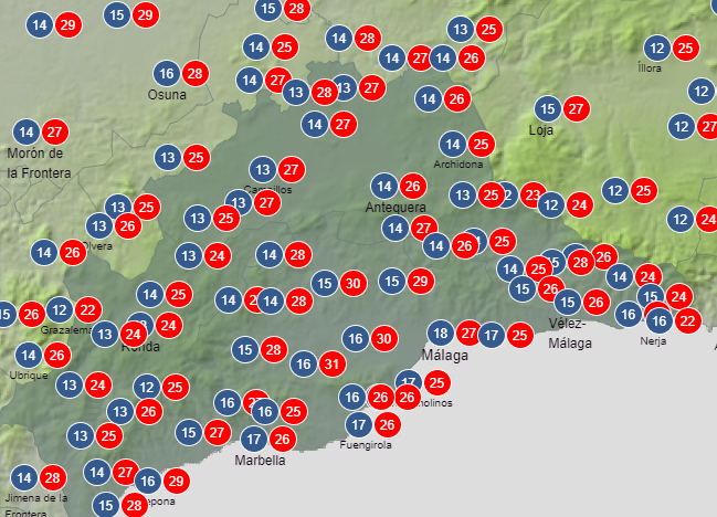
A general rise in temperatures will be noted on Friday 25 April, with the maximum possibly reaching 30C in the upper Guadalhorce valley area (Coín and Álora) on Saturday. This would exceed the highest temperature recorded this year so far, which was 28.2C on 29 March.
As for the forecast for today (Tuesday 22 April) and tomorrow, there is a very low risk of precipitation, more likely in the Torcal de Antequera area. "This could be the first week without rain for a while in Andalucía after many with," said the head of Spain's state Aemet meteorological centre in Malaga, Jesús Riesco.
From Wednesday, the anticyclone will arrive, serving as protection from the entry of storms from the Mediterranean. This, together with the so-called "subsidence phenomenon", will bring temperatures to 26C in Malaga city and the coast this weekend.
In meteorology, subsidence is the downward movement of air from the middle and upper layers of the atmosphere towards the surface. As it goes down, the air gets warmer. This phenomenon is usually associated with the arrival of anticyclones, generating stable conditions and warmer temperatures. Therefore, it must be differentiated from the warm 'terral' wind, which is not expected these days, according to Riesco.
José Luis Escudero, head of SUR's weather blog, 'Tormentas y Rayos', has confirmed that the heat this weekend will be more present in the upper Guadalhorce. According to him, people north of Malaga city could enjoy 27C, but temperatures closer to the beach will be 5-6C lower.
The main question many people are asking is: Is summer here already? Well, the answer is: not yet. From Wednesday 30 April onwards, forecasts leave the possibility of a new storm coming from the Atlantic open, although Aemet meteorologists have said that it is still too far away to make certain predictions about how it will affect Malaga province.
The last major rainfall was experienced last Tuesday, when two successive storms left 2mm in 10 minutes and another 1.2mm in half an hour in Malaga city. As Riesco pointed out, those downpours were "very difficult to predict", as they got stronger once they reached the city, and their intensity exceeded predictions for the day.
Publicidad
Publicidad
Publicidad
Publicidad
Esta funcionalidad es exclusiva para registrados.
Reporta un error en esta noticia

Debido a un error no hemos podido dar de alta tu suscripción.
Por favor, ponte en contacto con Atención al Cliente.
¡Bienvenido a SURINENGLISH!
Tu suscripción con Google se ha realizado correctamente, pero ya tenías otra suscripción activa en SURINENGLISH.
Déjanos tus datos y nos pondremos en contacto contigo para analizar tu caso
¡Tu suscripción con Google se ha realizado correctamente!
La compra se ha asociado al siguiente email

Comentar es una ventaja exclusiva para registrados
¿Ya eres registrado?
Inicia sesiónNecesitas ser suscriptor para poder votar.