Sections
Highlight
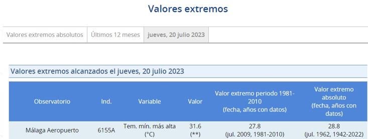
Last night Malaga experienced its warmest night since records have been kept in the province. The thermometers, according to the official Aemet gauge at the city's airport, did not drop below 30C. In addition, a new record minimum of 31.6 degrees was reached, the highest since 1942. The previous record, registered on 3 August 1949, was 29.4C, two degrees lower than the one recorded in the early hours of this Friday morning, according to Spain's state met office.
This morning, after two days of a experiencing red weather warnings for heat and registering record temperatures both during the day and at night, the Bay of Malaga has once again experienced very high minimum temperatures, around 28-29C.
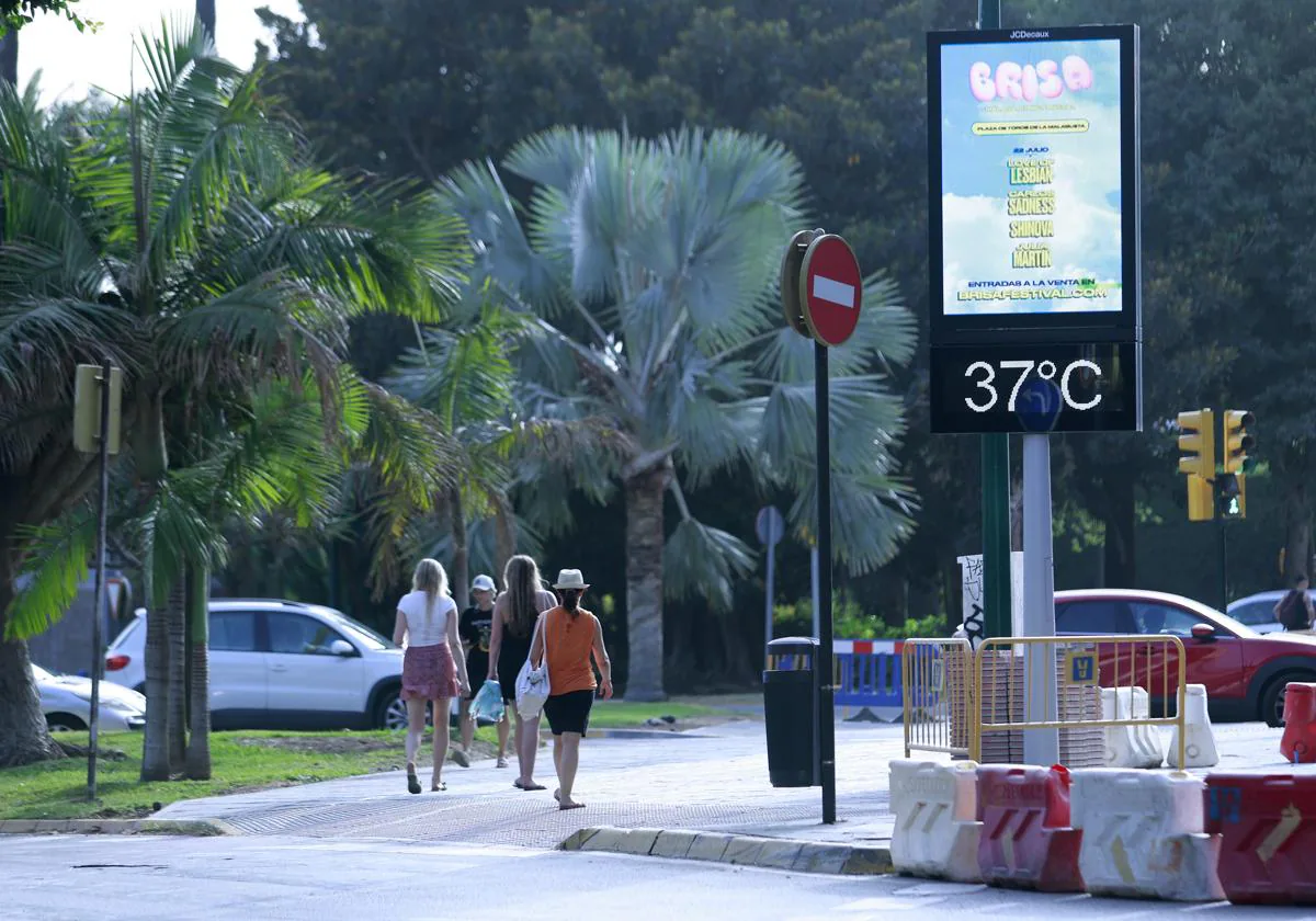
Today Aemet is forecasting the last day of the hot spell in Malaga, where the maximum temperature could reach 39 degrees, the highest among the Andalusian cities. The region of the Costa del Sol and Valle del Guadalhorce will be under a yellow heat warning from 1pm to 8.59pm.
The state meteorological agency forecasts lightly cloudy skies for this Friday, with intervals of medium and high clouds. Winds will blow from the west, and will be occasionally strong on the coast. Temperatures will experience a general drop after the high temperatures recorded this week and the heat wave will give way to milder temperatures at the weekend.
In the rest of the country, the mercury will also take a breather after the heat wave suffered in recent days. Temperatures will drop this 21 July across almost all of Spain, on a day when five regions will be on a yellow alert (risk) for storms, rain, heat, wind and high waves according to Aemet.
Northeastern regions, such as Catalonia and Aragon, will be on alert for rainfall and storms. Specifically, Huesca, Barcelona, Gerona and Lérida could accumulate up to 20mm metre in an hour. Rainfall is expected to be constant throughout the day, according to Europa Press. In addition, the rainfall will be accompanied by thunderstorms.
On the other hand, Gran Canaria, La Palma, La Gomera, El Hierro and Tenerife will be on yellow alert for strong gusts of wind, which will reach 70 km/h, and which will create high waves due to force seven north-easterly winds.
This day will also be marked by the heat in Murcia, which will be on yellow alert for high temperatures. The region could reach 39C. Friday will also be marked by the 'rissaga' in Menorca, which will cause sea level oscillations of almost one metre.
Likewise, early morning showers and thunderstorms are forecast in the Pyrenees, which will continue in the afternoon and may be locally heavy. In the rest of the northern half of the country there will be cloudiness, without occasional isolated showers and thunderstorms being ruled out. During the day there will be intervals of medium and high clouds in the southeast and the Balearic Islands, without ruling out occasional light rainfall in the Balearic Islands. In the Canary Islands, low clouds in the north of the islands are forecast by Aemet, without ruling out some light drizzle in the higher point of the islands.
Publicidad
Publicidad
Publicidad
Publicidad
Esta funcionalidad es exclusiva para registrados.
Reporta un error en esta noticia

Debido a un error no hemos podido dar de alta tu suscripción.
Por favor, ponte en contacto con Atención al Cliente.
¡Bienvenido a SURINENGLISH!
Tu suscripción con Google se ha realizado correctamente, pero ya tenías otra suscripción activa en SURINENGLISH.
Déjanos tus datos y nos pondremos en contacto contigo para analizar tu caso
¡Tu suscripción con Google se ha realizado correctamente!
La compra se ha asociado al siguiente email


Comentar es una ventaja exclusiva para registrados
¿Ya eres registrado?
Inicia sesiónNecesitas ser suscriptor para poder votar.