Walking at dizzying heights
Thrills. ·
Malaga province has some spectacular routes for those who like a bit of excitement when they hike, and, although they are safe, they are not advisable for anyone afraid of heightsSections
Highlight
Thrills. ·
Malaga province has some spectacular routes for those who like a bit of excitement when they hike, and, although they are safe, they are not advisable for anyone afraid of heightsJAVIER ALMELLONES
MALAGA.
Friday, 4 November 2022
What follows below is not for anyone who doesn't have a head for heights, but those who enjoy a bit of excitement while out hiking will undoubtedly find these, the most vertiginous routes in Malaga province, very tempting.
Thanks to its spectacular terrain, the countryside in Malaga offers thrills without risks. Nearly everyone will have heard of the Caminito del Rey and it is indeed truly impressive, but it is not the only option and new projects are also being planned for the future.
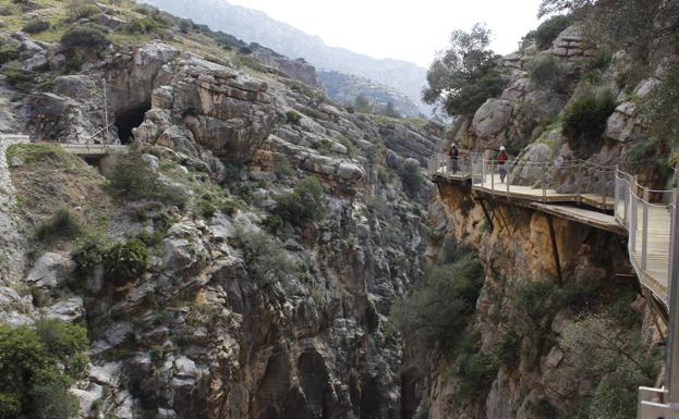
This is the most famous one on the list and it has inspired others in the province which are quite similar. It was restored in 2015 and since then has become one of Andalucía's most popular tourist attractions.
This high-altitude walkway above the Desfiladero de los Gaitanes gorge is a journey through the history and nature of the heart of Malaga province, and it makes a perfect day trip when combined with a visit to other beauty spots in the area such as the three reservoirs or to traditional villages like Ardales, Álora and Valle de Abdalajís.
The original walkway over this impressive karst gorge, situated between the Guadalhorce, Conde del Guadalhorce and Guadalteva reservoirs, had fallen into disrepair and was unusable. It had been built in the early 20th century for workers on the Conde del Guadalhorce dam, and its name - King's Path - comes from the visit by King Alfonso XIII in 1921 when he came to inaugurate the reservoir.
Its restoration and reopening was a landmark for tourism in Malaga province, thanks to its spectacular views down into the limestone gorge. A vertiginous hanging bridge with a transparent section of floor links the rock walls each side of the Desfiladero de los Gaitanes with the different landscapes, histories and ecologies of this beautiful rural area.
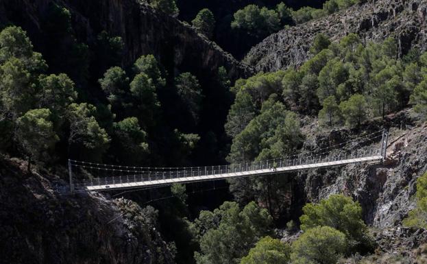
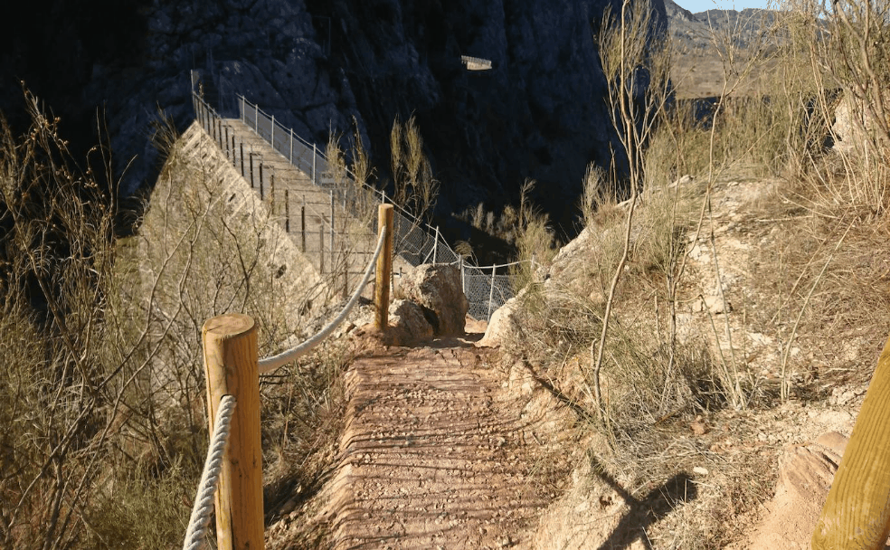
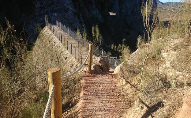
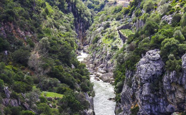
Since 2020 a hanging bridge over the Almanchares river in Canillas de Aceituno has been a new landmark on the Gran Senda de Malaga, a circular route through the province which totals 856 kilometres in length.
The bridge is 64 metres above the river and is 52 metres long and 1.20 wide. It is made of steel and has a wooden floor. The way it is suspended between the two sides of the gorge makes it very enticing for lovers of adventure tourism.
This viaduct has now become the main attraction on the seventh stage of the Gran Senda, which is between Cómpeta and Canillas de Aceituno, and the route has recently been improved at Canillas.
From Canillas de Aceituno it is just over five kilometres to the bridge, which is reached down a steep dirt track. Those who come back that way will find a hard haul ahead of them, but walkers who carry on towards Sedella will also face quite a technical and physical challenge along a very narrow path.
Just before reaching the downward track towards the bridge the route crosses a metal walkway which brings the Caminito del Rey to mind, as it is attached to the rock wall and with a wire security fence for part of the way. A little further on, if one were to ignore the route of the Gran Senda, there would be a similar one to cross as well.
Although some people refer to this as the Caminito del Rey of the Axarquía, this route has little in common with the one through the area around the Desfiladero de los Gaitanes. Their origins and length are different, and this one is not a major tourist attraction.
It is important to note that while the path between Ardales and Álora was designed for nearly all types of visitor, this one is only suitable for those who are accustomed to a certain level of difficulty when hiking and some pretty steep hills.
The bridge at El Saltillo should only be tackled by those with experience and aptitude and, of course, a head for heights.
This is a recent addition to the list of exciting walking routes and it is near the village of Montejaque, where part of the terrain is in the Sierra de Ronda and the rest in the Sierra de Grazalema.
This is an ambitious project where one of the features is the famous 'ghost reservoir', where the water kept disappearing whenever it was filled.
The track to Tavisnilla and the walkway over the Caballeros dam have now been restored as part of this project. The remarkable dam was built one hundred years ago, but a major error was made during the construction, and it was never able to be used for the purpose for which it was built. The ghost reservoir of Montejaque is one of many quirky peculiariies in the province of Malaga.
As well as the dam, another attraction in the area is the Cueva del Hundidero cave, which is part of a spectacular geological system that ends at the Cueva de Gato in the neighbouring village of Benaoján.
When designing this route, the authorities decided to link the dam with the Hundidero cave, which is classified as a natural monument of Andalucía. The first stretches of the route to open were the path across the dam and the track which leads down to the cave.
Not far from Cortés de la Frontera, between the hamlet of El Colmenar, and the Buitreras del Guadiaro there is a thrilling walk to one of the most spectacular gorges in Malaga province, which has also been classified as a natural monument of Andalucía because of its biological and geological value.
After a kilometre and a half along the track that goes to the left you can see a spectacular hanging bridge over the River Guadiaro, but this is just a taste of what is to come at Las Buitreras and its bridge - the Puente de los Alemanes.
Before reaching there, however, there is a steep climb to be done to the highest point on the route and this rocky enclave. It is well worth the effort, though, for the wonderful views.
The route can either stop there or go on to the Puente de los Alemanes, or another option would be to take a careful walk around the canyon to enjoy the natural surroundings of this valuable ecological enclave.
The rock walls of the Buitreras del Guadiaro gorge reach a height of 100 metres and in places it is barely one metre wide.
The karst complex is immensely valuable from a geological point of view because one of its vertical rock walls dates back to the Jurassic period, millions of years ago.
Adventure tourism has really taken off in the countryside behind the Costa del Sol and other projects are in the pipeline for those who like their hikes to provide some excitement along the way. One to look out for in the future is the Camino del Desfiladero del Tajo in Ronda, which promises to be a dizzying but safe route through stunning scenery.
Publicidad
Publicidad
Publicidad
Publicidad
Esta funcionalidad es exclusiva para registrados.
Reporta un error en esta noticia

Debido a un error no hemos podido dar de alta tu suscripción.
Por favor, ponte en contacto con Atención al Cliente.
¡Bienvenido a SURINENGLISH!
Tu suscripción con Google se ha realizado correctamente, pero ya tenías otra suscripción activa en SURINENGLISH.
Déjanos tus datos y nos pondremos en contacto contigo para analizar tu caso
¡Tu suscripción con Google se ha realizado correctamente!
La compra se ha asociado al siguiente email
Comentar es una ventaja exclusiva para registrados
¿Ya eres registrado?
Inicia sesiónNecesitas ser suscriptor para poder votar.